Marine Navigation
by Marco Palaferri
Version 10,000+ 💾 18 Mb
📅 Updated Eligible if bought after 7/2/2016.
Learn
Offline GPS tracker for boat navigation. GPS Chartplotter for Sailing & boating

Features Marine Navigation
MARINE NAVIGATIONFind your road on the sea!
GPS chartplotter for boating.An easy-to-use offline GPS tracker and route planner featuring worldwide offline maps.Buy once and for all, without any subscriptionNavigate with your favorite device around the world, turn your smartphone or tablet into a GPS navigator with an offline map, ideal for sea, rivers and lakes, for boaters, fishermen and water sports.
This application is dedicated to the sea and the people who love it and live it with passion.WHAT MAKES IT A BEST GPS TRACKER OR NAVIGATOR:Offline GPS tracker for boat navigation.
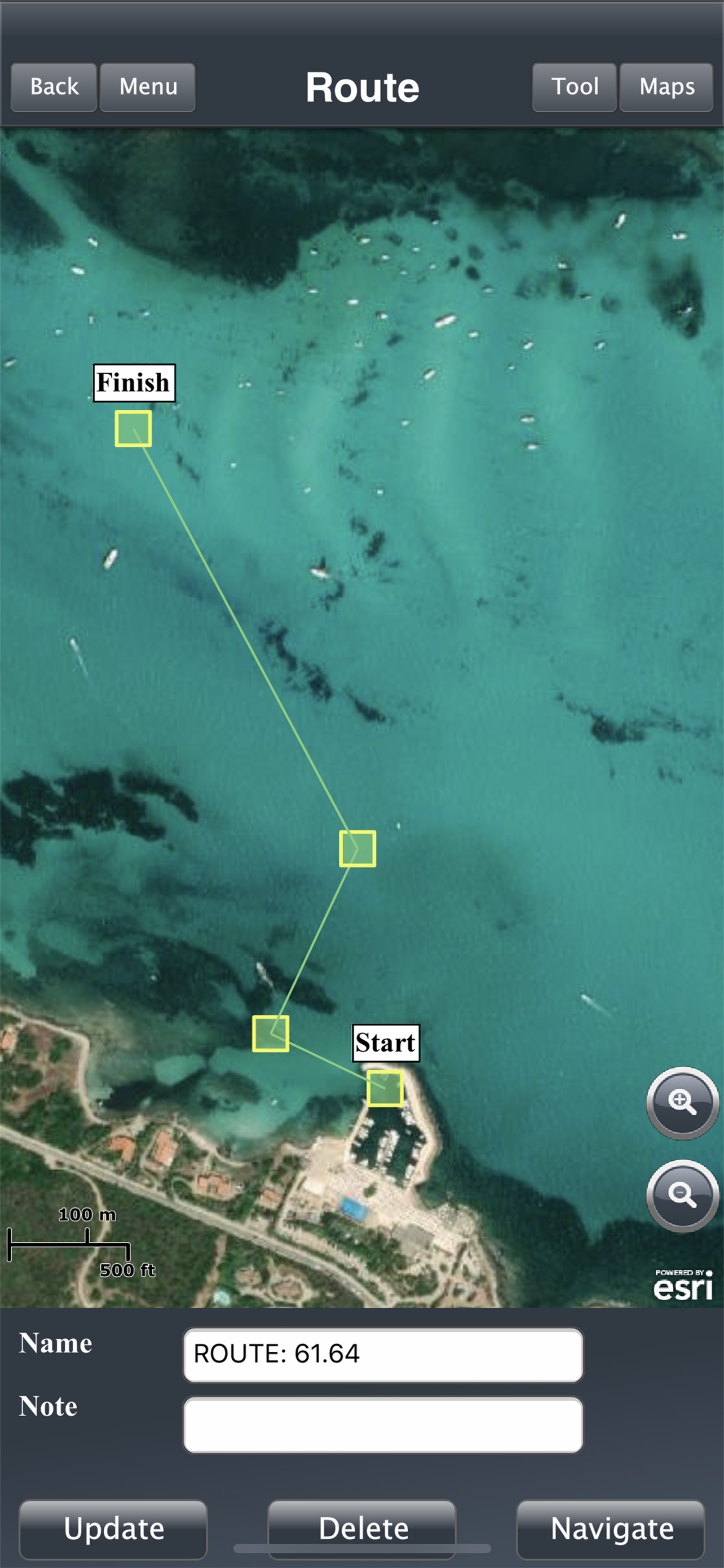
GPS Chartplotter for Sailing & boating.Morse Code in case of danger, Anchor Alert to prevent the drift of the anchor, Moon Phase to show the phases of the moon during the day, Harbors to see the list of ports, Sync Waypoints to be able to create backups and access them from different devices.You also get to download the maps and marine charts, so you won’t need an active internet connection when it comes to getting navigation and route planning.
If you create a profile, you can save waypoints and routes to access them from different devices.
All you have to do is logging in with the same account and enjoy seamless sea GPS navigations.So, no matter you are a professional sailor or fisherman, or you are an amateur who like traveling in the sea, Marine Navigation has got you covered.
It’s a versatile sea navigator app and boating route planner which provides accurate GPS Chartplotter and marine charts.
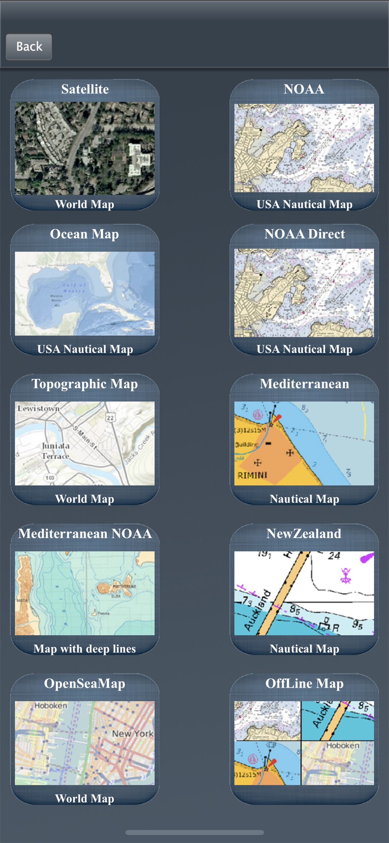
MAPS OFFLINE:You can download maps or marine charts, you need a select area and application save tile into your device.
You can navigate on preloaded maps or charts without connection.MAPS AND MARINE CHARTS:MapView: http://www.fishpoints.net/mapsview/•Nautical maps of the United States of America by NOAA •Nautical maps of the Mediterranean by NOAA •Mediterranean RNC •Nautical maps of the NewZealand by LINZ •Maps of the world’s oceans and coastal areas by ESRI •World topographic map includes boundaries, cities, water features, ports, physiographic features by ESRI •Satellite imagery for the world by ESRI •Maps for the sea, with ports, sea light and more by Open Sea Map Marine Navigation: GPS Tracker Main Features at a Glance•Super easy to use GPS tracker tool•Clean and neat design •Available in different languages: English, Italian, French, Spanish, Brazilian, Turkish and German,Indonesian•Download Maps to use in offline mode•Accurate and detailed GPS Chartplotter, GPS plotter and Marine charts•Optimized for phones and tablets•Sync routes and waypoints to access them anywhere from any devices•Moon phase•Morse Code•Receive information about speed, direction, time to arrival•Compass•Change Measurement Units: Km, Mi, or Nmi•Record your route for analyze the data and renavigate your traceLOCATION PERMISSIONThe app needs your location to trace the route on the map.Location information is processed locally on your device, ensuring your privacy.HELP USDownload Marine Navigation and let us know about any bugs, feature requests or any other suggestions.
Stay tuned for more features and options in this GPS tracker app for boating.WARNINGGood seamanship requires the use of official charts.
Marine Navigation is for use with other charts and cannot replace official charts.
Use at your own risk.LEARN MORE ABOUT FISHPOINTS http://www.fishpoints.net A link to the terms of use: http://www.fishpoints.net/eula/A link to the privacy policy: http://www.fishpoints.net/privacy-policy7.3.34(2021-03-28)•Improved Route Creator•GPX for Single Waypoint or Route6.3.66(2021-08-31)•BugFix6.3.60(2021-08-31)•Increase GPS Precision•Magnetic or True Compass•Record Route & Normal Route View Information•Navigation View: Information inside viewfinder•Navigation View: Reposition to location after map moved •Navigation View: New Interactive North Icon6.3.42(2021-08-17)-BugFix Provider Google Play6.3.41(2021-08-16)-BugFix
Secure & Private
Your data is protected with industry-leading security protocols.
24/7 Support
Our dedicated support team is always ready to help you.
Personalization
Customize the app to match your preferences and workflow.
See the Marine Navigation in Action
What Our Users Say
Don't just take our word for it. Here's what our users have to say about our Android app.
"Impossible to figure out how to access NOAA inshore maps for Texas USA."
b welcing
"This app would be the biggest waste of money ever. A complete scam. Bad detail of NZ and the area I wanted it for is blank. DO NOT purchase thus app."
R
"Useless app"
Sanjay Singh
"Doesn't work"
Zuhair Khalaf
"I have paid the money still it is not working."
MAHMED ARIF
"Easy to use. All information clear. Simple menu. I have used for many years."
Rod Blake
"Cannot install after payment"
Hussain Shakeel
"It's worse app"
SEZEF 13
"awesome app!!!"
Jason Westphal
"Works pretty well off Panama City Beach"
Enerald Coast
Get the App Today
Available for Android 8.0 and above